Birmingham City Council
Tree preservation zone
There is a problem
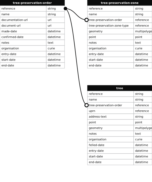
- 1000 entries with tree-preservation-order field must match the reference field in the tree preservation order dataset
THE BIRMINGHAM (REDDICAP KENNELS AND LAND REAR OF REDDICAP HILL, SUTTON COLDFIELD) TPO 1984
- reference
- 438
- name
- THE BIRMINGHAM (REDDICAP KENNELS AND LAND REAR OF REDDICAP HILL, SUTTON COLDFIELD) TPO 1984
- tree-preservation-order
- TPO 438
- tree-preservation-zone-type
- area
- geometry
- MULTIPOLYGON (((-1.808904 52.559738,-1.808921 52.559508,-1.808922 52.559463,-1.808922 52.559417,-1.808910 52.559273,-1.808908 52.559196,-1.808921 52.559155,-1.808954 52.558975,-1.808950 52.558913,-1.808959 52.558819,-1.808969 52.558815,-1.808926 52.558810,-1.808720 52.558776,-1.808623 52.558763,-1.808539 52.558749,-1.808479 52.558741,-1.808088 52.558671,-1.808088 52.558675,-1.807918 52.558642,-1.807925 52.558629,-1.807687 52.558589,-1.807587 52.558565,-1.807297 52.558402,-1.806811 52.558136,-1.806769 52.558076,-1.806750 52.558080,-1.806725 52.558048,-1.806544 52.557800,-1.806441 52.557663,-1.806411 52.557615,-1.806395 52.557599,-1.806191 52.557330,-1.806269 52.557292,-1.806397 52.557232,-1.806478 52.557196,-1.806688 52.557097,-1.806672 52.557090,-1.806544 52.557021,-1.806400 52.556939,-1.804775 52.557700,-1.805049 52.557909,-1.805166 52.558001,-1.804712 52.558256,-1.804684 52.558236,-1.804335 52.558447,-1.804456 52.558516,-1.804638 52.558636,-1.804760 52.558708,-1.804771 52.558713,-1.804791 52.558727,-1.804991 52.558829,-1.805189 52.558856,-1.805269 52.558861,-1.805306 52.558872,-1.805258 52.559041,-1.805210 52.559168,-1.805151 52.559348,-1.805075 52.559514,-1.805303 52.559546,-1.805235 52.559753,-1.805217 52.559802,-1.805196 52.559880,-1.805184 52.559908,-1.805167 52.559990,-1.805444 52.560012,-1.805454 52.560014,-1.805482 52.560013,-1.805724 52.560024,-1.805789 52.560033,-1.805907 52.560042,-1.805943 52.559882,-1.805969 52.559743,-1.806006 52.559746,-1.806042 52.559608,-1.806097 52.559612,-1.806157 52.559287,-1.806406 52.559402,-1.806332 52.559449,-1.806309 52.559557,-1.806312 52.559577,-1.806544 52.559607,-1.806548 52.559548,-1.806745 52.559554,-1.806918 52.559566,-1.807038 52.559568,-1.807355 52.559583,-1.807354 52.559590,-1.807735 52.559599,-1.807803 52.559602,-1.807790 52.559717,-1.807773 52.559896,-1.807762 52.559987,-1.807885 52.559984,-1.807923 52.559976,-1.807968 52.559954,-1.807997 52.559933,-1.808038 52.559909,-1.808085 52.559889,-1.808113 52.559881,-1.808203 52.559864,-1.808407 52.559830,-1.808476 52.559817,-1.808574 52.559793,-1.808635 52.559775,-1.808719 52.559754,-1.808728 52.559750,-1.808761 52.559743,-1.808804 52.559738,-1.808859 52.559736,-1.808904 52.559738)))
- point
- POINT (-1.806542 52.558747)
- notes
- The shaded area represents those properties which fall within the outline of a Tree Preservation Order. To precisely identify trees protected by the Order, you can request a copy of the tree preservation order at the following link.
- entry-date
- 2026-10-15
- start-date
- end-date
How to fix this issue
Your data is missing a tree-preservation-order.
The tree preservation zone guidance explains how to fix the issue:
tree-preservation-order
The reference for the tree preservation order that covers this zone.
How to improve Birmingham City Council’s data
- Fix the errors indicated
- Use the check service to make sure the data meets the standard
- Publish the updated data on the endpoint URL